A View of Planet Earth With Summer - Page 5
 |
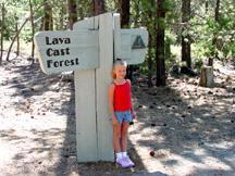 |
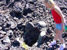
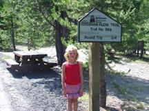
We next headed for the Lava Cast Forest. Here, a trail loops through an area where hot molten lava once erupted from the northwest flank of Newberry Volcano and engulfed a forest of mature ponderosa pine trees about 6 to 7 thousand years ago. Molten lava enveloped the pine trees and quickly cooled around them, while at the same time the trees either burned or later rotted out leaving holes in the hardened lava in the shape of the former trees. The landscape now includes numerous molds of these ancient trees that are identified by deep round holes left in the lava. It was interesting to see the holes left behind and to analyze the features of the molds. In some cases, you could tell the direction in which the lava flowed by observing a mound of lava on one side of the remaining hole caused by the moving lava piling up against the tree. Where the lava flowed faster, it pushed over the trees and molds were then formed around some of them. Summer could actually crawl into some of these tunnel molds and hide. Although this lava flow occurred a long time ago, it almost looks like it occurred yesterday because of the stark contrast between the barren rocks and the surrounding lush forest. There are places where small plants are taking root (such as Wild Huckleberry, Indian Paintbrush, mosses, and some lichen), but its going to take thousands of more years before weathering of the lava will create enough soil to support another forest.
 |
 |
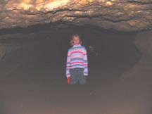 |
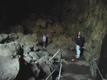
Our next adventure, which really caught the interest of Summer, was the exploration of a mile long lava tube. It was a hot day, but it was a perfect day for going into the 42-degree Lava River Tube that was located a short distance from the Lava Cast Forest. This is Oregon's largest uncollapsed lava tube, created when the upstream source of a moving stream of molten lava stopped and the remainder of the lava in it's interior drained out of its far end. It then left a meandering tunnel that in this case is as large as 30 feet wide by 50 feet high in places and then narrows to just a few feet at the far end. We were prepared with warm clothes and flashlights as we descended the few steps into the depths of this long cave. We were on our own on this venture as there are no guides, but there were plenty of other people who were doing this too. Some were carrying lanterns that they had rented at the entrance to the cave. The cave is not lighted, so we needed to depend on our flashlights or the lights of others to see our way and to watch our footing. Most of the walking was on firm sand with little need to scramble over obstacles. It was interesting to shine a light on the cavern walls and see the way lava had pored through the tube. In places, you could see benches along the sides created by various levels of the flowing lava. At one point, there was a sign indicating that interstate highway 97 was 80 feet directly overhead. Summer was determined to find the end of the cave and she ended up crawling about a hundred feet on her hands and knees under the low ceiling before deciding to turn around.
 |
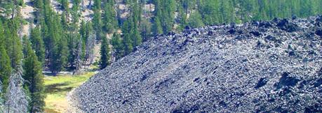 |
Our next stop was at the Big Obsidian Flow within the caldera of Newberry Volcano, which was the last and most recent volcanic activity from the volcano that occurred 1,300 years ago and is now the youngest volcanic feature in central Oregon. Obsidian rock has a high concentration of silica and is like a "hardened liquid" that never got a chance to form into a crystallized structure (it's atoms were never able to arrange themselves in an orderly fashion before its mass cooled). It is said that the outflow of this material moved slowly, probably only a few feet a day, oozing a thick viscous mass down the southeast side of the inner caldera wall. It is about 6,000 feet long and up to 65 feet in depth. The Obsidian here is a dark black glass like rock that has been quite valuable to native peoples of this area for centuries (and longer). They used it for spear and arrow points, and for knives. Even today it is used in surgical instruments because it is sharper than steel..
 |
Obsidian artifacts from this site have been found in many places in Oregon and Washington, having been traded by the Indians as an economic product. In fact, archaeologists have uncovered several sites of ancient human activity here in the caldera including quarries, work sites, and campsites that are nearly 9,000 years old. It is very easy to see that the earliest native peoples here probably experienced many volcanic events and that many of their campsites were probably buried by pumice, ash, and lava. It is reported that there are at least 6 other older obsidian flows in the caldera and it is known that many eruptions have taken place over those years, including the mighty cataclysmic event that created Crater Lake, which is about 75 miles to the south. Some native artifacts have been recovered from under layers of ash here, including a sandal made of sagebrush bark.
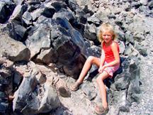
After previously looking at this obsidian flow from high up on Paulina Peak, we were now down at its level and ready to do some close inspection. We took the interpretive trail up to the top of the obsidian flow and surveyed all the glistening (and sharp) black rocks. Signs warned of the dangers of handling the rocks and of the wearing of sandals to walk the trail. Summer had never seen so much glass in one area.
 |
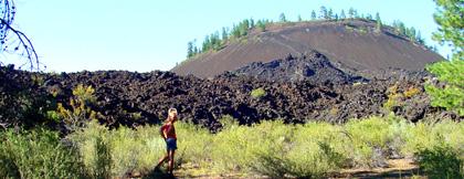 |
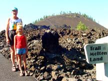
Our final stop was Lava Butte, a 500 foot high cinder cone and one of many that erupted from fissures in the flanks of Newberry Volcano about 7,000 years ago. Lava also erupted from this cone, traveling 6 miles and covering over 9 square miles. Here, there is a visitor and interpretive center that serves as the hub of the Newberry National Volcanic Monument. This place offers nature walks, interpretive programs, and displays on geology, volcanology, and on the cultural history of the area. Behind this facility are two self guided interpretive trails, which we hiked; the Trail of Molten Land, and the Trail of Whispering Pines. The Trail of Molten Land took us through the lava flow and up near the cinder cone. Interpretive signs along the way pointed out various volcanic features.